
Monday, September 04, 2006
updated route
as requested by aLex, and to give you a better idea of where i have been and where i am going, i am providing an updated route. the yellow line is where i have been, and the purple line is where i plan on going. the planned route is pretty accurate through las vegas. after that, it is still a little up in the air, but generally accurate. if there is anything between las vegas and chicago that you think i should see or do, please let me know and i will try to work it in.


day 23
twelve years ago today (09/03/1994) aLex and i got married. it was inevitable. i am sad that i could not share this day, what i saw, what i did, and how i felt with her. i was thinking about her all day, wishing she could be with me, not just today, but for this whole journey. i owe her so much for allowing me to do this. she has sacrificed so much while i am on this trip, time, sleep, help, my company, that i cannot possibly repay her for this. i know that there will be plenty of chicken enchilada dinners when i get back.
as we are highly competitve with each other (big hill in washington park, springfield, il), she now has her own blog. it was after reading hers that i figured out how to do web links instead of inserting the url into the text. i went back in my entries an fixed a few of the longer links. i look forward to reading it every day to see how she is doing.
it was a relatively quick ride to yosemite, and i already had my route planned out to see the major sites. once i got in the park, traffic was pretty bad, but the roads and, more importantly, the road surface were quite good, making the twists much more easy to ride through. below are some of the impressive sights.

el capitan, yosemite, ca - 09/03/2006
aLex is always so good at taking these type of self-portraits. i hope this one meets her approval.

pedro and el capitan, yosemite, ca - 09/03/2006
on the way to mariposa grove, there is a great view of yosemite valley, with el capitan on the left and half dome in the background.

yosemite valley, yosemite, ca - 09/03/2006
this fallen giant sequoia, called "fallen monarch" is estimated to have fallen over 300 years ago. in 1899, the u.s. cavalry took a picture on this tree.
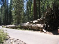
fallen monarch, mariposa grove, yosemite, ca - 09/03/2006
this giant sequoia, known as the "grizzly giant", is estimated to be over 2700 years old. to get an idea of its size, notice the group of people standing at the base of the tree.

grizzly giant, mariposa grove, yosemite, ca - 09/03/2006
after visiting mariposa grove, i headed along the tioga pass road, which crosses the pass at an elevation of 9945 feet. the road winds through granite domes and open meadows. this picture is looking west west, with tenaya lake in the middle.

tioga pass, yosemite, ca - 09/03/2006
after leaving yosemite, it was a nice ride to bishop, ca. i rode through the inyo national forest and owens valley. this picture is looking southwest from just north of bishop, ca.

owens valley, north of bishop, ca - 09/03/2006

as we are highly competitve with each other (big hill in washington park, springfield, il), she now has her own blog. it was after reading hers that i figured out how to do web links instead of inserting the url into the text. i went back in my entries an fixed a few of the longer links. i look forward to reading it every day to see how she is doing.
it was a relatively quick ride to yosemite, and i already had my route planned out to see the major sites. once i got in the park, traffic was pretty bad, but the roads and, more importantly, the road surface were quite good, making the twists much more easy to ride through. below are some of the impressive sights.

el capitan, yosemite, ca - 09/03/2006
aLex is always so good at taking these type of self-portraits. i hope this one meets her approval.

pedro and el capitan, yosemite, ca - 09/03/2006
on the way to mariposa grove, there is a great view of yosemite valley, with el capitan on the left and half dome in the background.

yosemite valley, yosemite, ca - 09/03/2006
this fallen giant sequoia, called "fallen monarch" is estimated to have fallen over 300 years ago. in 1899, the u.s. cavalry took a picture on this tree.


fallen monarch, mariposa grove, yosemite, ca - 09/03/2006
this giant sequoia, known as the "grizzly giant", is estimated to be over 2700 years old. to get an idea of its size, notice the group of people standing at the base of the tree.

grizzly giant, mariposa grove, yosemite, ca - 09/03/2006
after visiting mariposa grove, i headed along the tioga pass road, which crosses the pass at an elevation of 9945 feet. the road winds through granite domes and open meadows. this picture is looking west west, with tenaya lake in the middle.

tioga pass, yosemite, ca - 09/03/2006
after leaving yosemite, it was a nice ride to bishop, ca. i rode through the inyo national forest and owens valley. this picture is looking southwest from just north of bishop, ca.

owens valley, north of bishop, ca - 09/03/2006
Saturday, September 02, 2006
day 22
today was pretty much a maintenance and rest day. i had most of the trip planned out up to this point, but the rest ws just some ideas of things i would like to see or do. no real plan on how i would do them all or in what order. i think i at least have through next weekend planned out.
tomorrow i am going to yosemite and will try to hit zion, bryce canyon, and the grand canyon before meeting alex again in las vegas.
tomorrow i am going to yosemite and will try to hit zion, bryce canyon, and the grand canyon before meeting alex again in las vegas.
day 21
instead of heading straight down 101 to muir woods, which would have taken about 30 minutes, i decided to head to the coast and take highway 1. it took over two hours to get to muir woods along this route due to the winding roads, rough pavement, and construction, but it was worth it. it was a challenging ride, but i saw things i never would have seen on 101. while going up and down the hills and mountains and moving closer and further from the ocean, the tempurature changed many times, varying by about 30 degrees.
the first picture below is from the route to highway 1, looking back at the road i just rode on with the hillsides in the background. i think those are hawks in the sky circling over something. once i got to highway 1, there were many small fishing towns along the way. this second photo is one of the old fishing boats in tomales bay. continuing down highway 1, i rode between the point reyes national seashore and the golden gate national recreation area. the third picture is the ocean fog rolling in over the hills of point reyes.

along marshall-petaluma rd, ca - 09/01/2006

tomales bay, ca - 09/01/2006

fog rolling in over point reyes, ca - 09/01/2006
the section of highway 1 just south of stinson beach to muir woods was extremely winding and treacherous. there were dozons of hairpin turns with posted speeds of 10 to 15 mph; there were usually steep cliffs off to the side with no guard rails; and the road surface was extremely uneven, often going down to one lane due to slide where part of the roadway fell toward the ocean.
once i got to muir woods (thanks mike), i knew i wasn't going to make it all the way through my original itinerary for the day, so i decided to spend some more time here and cut the route short. i was very glad i did.
i took the long trail and was amazed by not only the trees, but also the history of muir woods, john muir, and his importance regarding the national park service. near the end of the trail, i asked one of the park volunteers about some trees that i rode through on highway 1 north of the park. he told me that they were blue gum eucalyptus and went into a 20 minute explanation of their history, how they were introduced to california from australia in the 1800s, and the problems they have caused in california. the most interesting story he had was the role these trees played in the 1991 oakland hills fire and how the oils in the trees causes them to explode.

walking among giants, muir woods, ca - 09/01/2006

old and new, muir woods, ca - 09/01/2006

"small" grove, muir woods, ca - 09/01/2006
after spending a few hours at muir woods, i knew i had to make some progress on my route, even though i already knew i had to cut it short. after riding for almost three weeks on secondary roads with limited traffic, i was not too excited to ride around san francisco on major highways on the friday afternoon of labor day weekend. most of my concerns were met or exceeded.
it wasn't too bad while i was north of san francisco and oakland. i even got to go over the richmond-san rafael bridge. once i got to oakland, though, it got pretty bad. there were times when it was about 10 miles per hour for about 20 mintues. there were tons of motorcyles riding between the slowed to stopped cars, called lane splitting, which is legal in california. some were going only slightly faster than traffic, but others were really flying.
for quite a while i didn't even consider it, but after about an hour sitting in traffic, i gave it a try. i set a rule for myself that i would only do it if traffic was going less than 15 miles per hour. i also didn't allow myself to go to0 fast. it ended up being pretty easy and i really did feel safe doing it. if i was going too slow and there were other motorcycles behind me, i would move back into traffic and let them pass me. i think it ended up saving me about an hour of travel time over about two and one-half hours.
the long day, the traffic, and the over 90 degree heat caused me to stop even earlier than i had planned. i might take a break on saturday to catch up on laundry and reassess my itinerary for the next few days, taking into account the labor day weekend and warm weather in the southwest.
the first picture below is from the route to highway 1, looking back at the road i just rode on with the hillsides in the background. i think those are hawks in the sky circling over something. once i got to highway 1, there were many small fishing towns along the way. this second photo is one of the old fishing boats in tomales bay. continuing down highway 1, i rode between the point reyes national seashore and the golden gate national recreation area. the third picture is the ocean fog rolling in over the hills of point reyes.

along marshall-petaluma rd, ca - 09/01/2006

tomales bay, ca - 09/01/2006

fog rolling in over point reyes, ca - 09/01/2006
the section of highway 1 just south of stinson beach to muir woods was extremely winding and treacherous. there were dozons of hairpin turns with posted speeds of 10 to 15 mph; there were usually steep cliffs off to the side with no guard rails; and the road surface was extremely uneven, often going down to one lane due to slide where part of the roadway fell toward the ocean.
once i got to muir woods (thanks mike), i knew i wasn't going to make it all the way through my original itinerary for the day, so i decided to spend some more time here and cut the route short. i was very glad i did.
i took the long trail and was amazed by not only the trees, but also the history of muir woods, john muir, and his importance regarding the national park service. near the end of the trail, i asked one of the park volunteers about some trees that i rode through on highway 1 north of the park. he told me that they were blue gum eucalyptus and went into a 20 minute explanation of their history, how they were introduced to california from australia in the 1800s, and the problems they have caused in california. the most interesting story he had was the role these trees played in the 1991 oakland hills fire and how the oils in the trees causes them to explode.

walking among giants, muir woods, ca - 09/01/2006

old and new, muir woods, ca - 09/01/2006

"small" grove, muir woods, ca - 09/01/2006
after spending a few hours at muir woods, i knew i had to make some progress on my route, even though i already knew i had to cut it short. after riding for almost three weeks on secondary roads with limited traffic, i was not too excited to ride around san francisco on major highways on the friday afternoon of labor day weekend. most of my concerns were met or exceeded.
it wasn't too bad while i was north of san francisco and oakland. i even got to go over the richmond-san rafael bridge. once i got to oakland, though, it got pretty bad. there were times when it was about 10 miles per hour for about 20 mintues. there were tons of motorcyles riding between the slowed to stopped cars, called lane splitting, which is legal in california. some were going only slightly faster than traffic, but others were really flying.
for quite a while i didn't even consider it, but after about an hour sitting in traffic, i gave it a try. i set a rule for myself that i would only do it if traffic was going less than 15 miles per hour. i also didn't allow myself to go to0 fast. it ended up being pretty easy and i really did feel safe doing it. if i was going too slow and there were other motorcycles behind me, i would move back into traffic and let them pass me. i think it ended up saving me about an hour of travel time over about two and one-half hours.
the long day, the traffic, and the over 90 degree heat caused me to stop even earlier than i had planned. i might take a break on saturday to catch up on laundry and reassess my itinerary for the next few days, taking into account the labor day weekend and warm weather in the southwest.
Friday, September 01, 2006
day 20
i had some trouble getting started getting started this morning. i am having some trouble getting this posted tonight as well. i don't know if has anything to do with the fact that i almost half way through this trip and am not sure what, if anything, i should feel i have accomplished.
anyway, i started out down the coast and took the picture below. while taking the photo, a tourist with a camera in his hand walked up to me. at first i though he wanted me to take his picture. it turned out he was german and wanted to know if i was german, too, due to the red, yellow, and black luggage on my bike. he actually wanted to take a picture or me.

california coast south of crescent city - 08/31/2006
i then checked out the redwoods and had a nice ride through the enormous trees. to give you an idea of the size...

avenue of the giants - 08/31/2006

avenue of the giants - 08/31/2006

avenue of the giants - 08/31/2006
the rest of the day was mainly just a fun ride down the 101 to just north of san francisco. i totally spaced on the holiday weekend, so i am trying to find places to stay for the next few nights. most of the campgrounds are already booked.
anyway, i started out down the coast and took the picture below. while taking the photo, a tourist with a camera in his hand walked up to me. at first i though he wanted me to take his picture. it turned out he was german and wanted to know if i was german, too, due to the red, yellow, and black luggage on my bike. he actually wanted to take a picture or me.

california coast south of crescent city - 08/31/2006
i then checked out the redwoods and had a nice ride through the enormous trees. to give you an idea of the size...

avenue of the giants - 08/31/2006

avenue of the giants - 08/31/2006

avenue of the giants - 08/31/2006
the rest of the day was mainly just a fun ride down the 101 to just north of san francisco. i totally spaced on the holiday weekend, so i am trying to find places to stay for the next few nights. most of the campgrounds are already booked.
Subscribe to:
Posts (Atom)


